Introducing Appenzell – Unrivalled Scenery In The Swiss Alps
Last Updated on
There are – truly – a few places I’ve visited where I’ve REALLY wanted to come back and shout about my experience and share it with you all.
But there are very few that, despite wanting to tell you all about it, I also want to keep it a secret.
Hiking in the Swiss Alps around Appenzell is one of those experiences.
Back in December 2017, I was reading the in-flight easyJet magazine and I came across an article that spoke of the great hiking in Switzerland, and specifically, the whisky trek.
A double page spread of the article showed an incredible alpine view, with a mountain hut, literally hugging the rock next to a sheer cliff face (see the pic below).
I was hooked.
And less than two years later, a friend and I were on our way to the North East of Switzerland, to hike the whisky trek in the Swiss Alps.
INTRODUCING APPENZELL
You can read more about the whisky trek in the link above, and if you’re not a fan of the hard stuff but love hiking and Alpine scenery, then read on.
After landing in Zurich we jumped in our hire car and took the one hour drive East to Appenzell. As we approached the town, lush green rolling fields, dotted with barns, farms and cows became the norm.
Everywhere was tidy, and everything was pristine, from manicured lawns to the local beer (Appenzellerbier) served in every establishment in town.
I didn’t know what to expect from Appenzell, but after walking to the town centre and watching local farmers guide their cow-bell-wearing dairy cows through the streets, in became apparent we were somewhere quite unique.
‘You could say that about many places, Simon’. Indeed you can.
But aside from the friendly cows and Truman Show like appearance, Appenzell is incredibly sustainable. It makes it’s own beer, milk, butter, cheese, bread, meat, sausage, internationally acclaimed, award-winning whiskies, and has world class hiking on its doorstep.
You can’t say that about many places.
THREE OF THE BEST SWISS ALPS HIKES
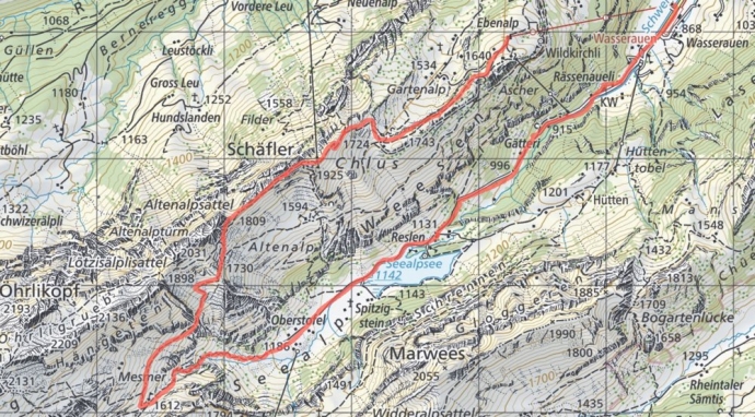
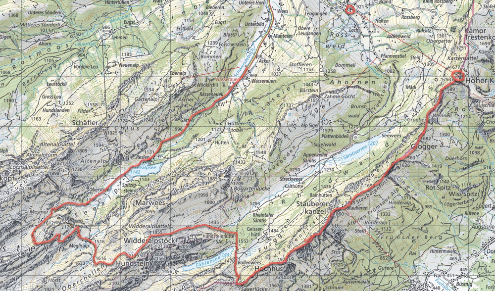
The whisky trek takes in some of the route of the ‘Royal Tour Of The Alpstein’, as shown on the Appenzell tourist website. Sadly it doesn’t show you how difficult some of the paths are, or where the best views can be found, so let me elaborate 🙂
If staying in Appenzell, I would recommend getting the train to Wasserauen. The train takes 11 minutes, and costs less than 6 CHF (return ticket). You can also drive to Wasserauen, as there is a huge car part just beyond the train station.
Wasserauen is also the location of the Ebenalp cable car. Simple cross the road, buy a ticket (one was costs 20 CHF) and away you go!
All three of the hikes shown below start at Wasserauen, and our first takes the cable car up to Berggasthaus Ebenalp.
A word of warning before you continue -Probably the most important element to consider when planning your Swiss Alps hike is the weather. For most people, the best time to hike these mountains would be mid to late Spring, and throughout summer to September. October and the winter months bring bitterly cold weather, ice and snow, and the Alpstein is far better suited to skiing than hiking in those months, unless you’re a seasoned winter orienteer.
1) WASSERAUEN > EBENALP > MESMER > SEEALPSEE > WASSERAUEN
- Estimated time – 4 hours
- Difficulty – moderate (precarious in one or two places)
The shortest of my three suggested Swiss Alps hikes, this day hike takes in the stunning scenery around Seealpesee. Once you arrive at the top of the cable car, double back on yourselves and enjoy the hike down to Berggasthaus Aescher. This little stretch of path has everything – caves, huts, paths on the side of the mountain, and finally Aescher comes into view as you wind round the corner. What a view.
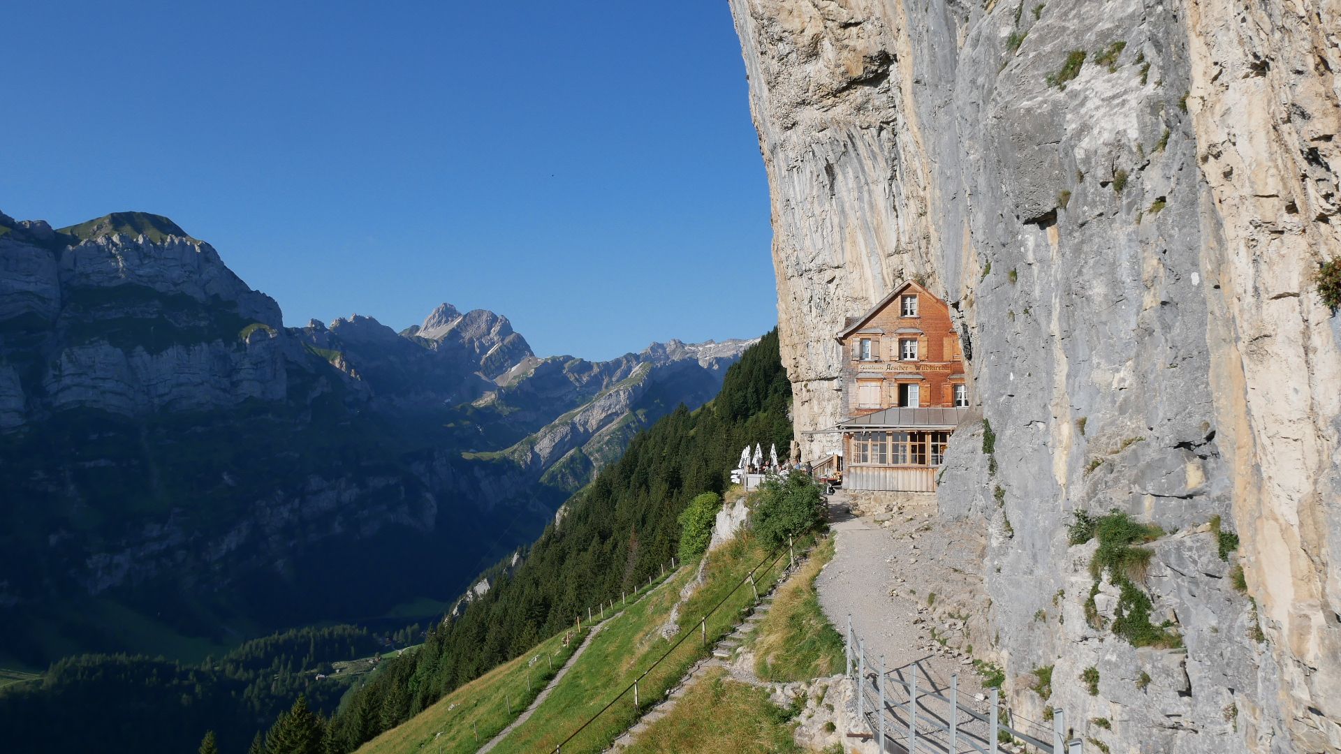
Berggasthaus Aescher
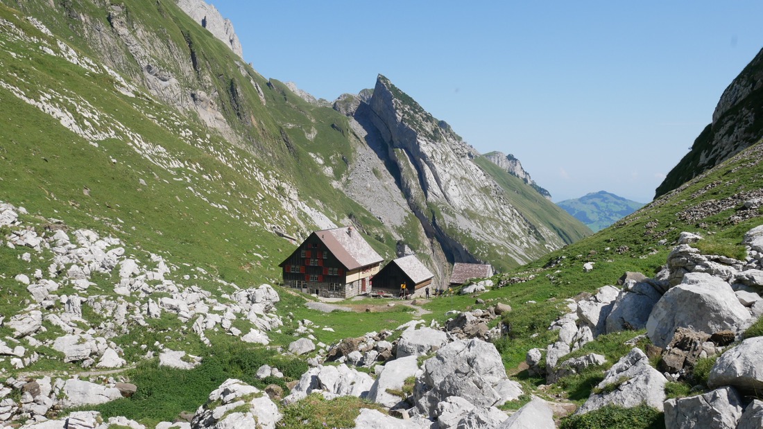
Hike back up to Ebenalp, taking in the views of Santis – the highest point in the Alpstein at 2503m – if the weather is clear. You should also be able to spot Berggasthaus Schafler at this point too, which is where you’re aiming for.
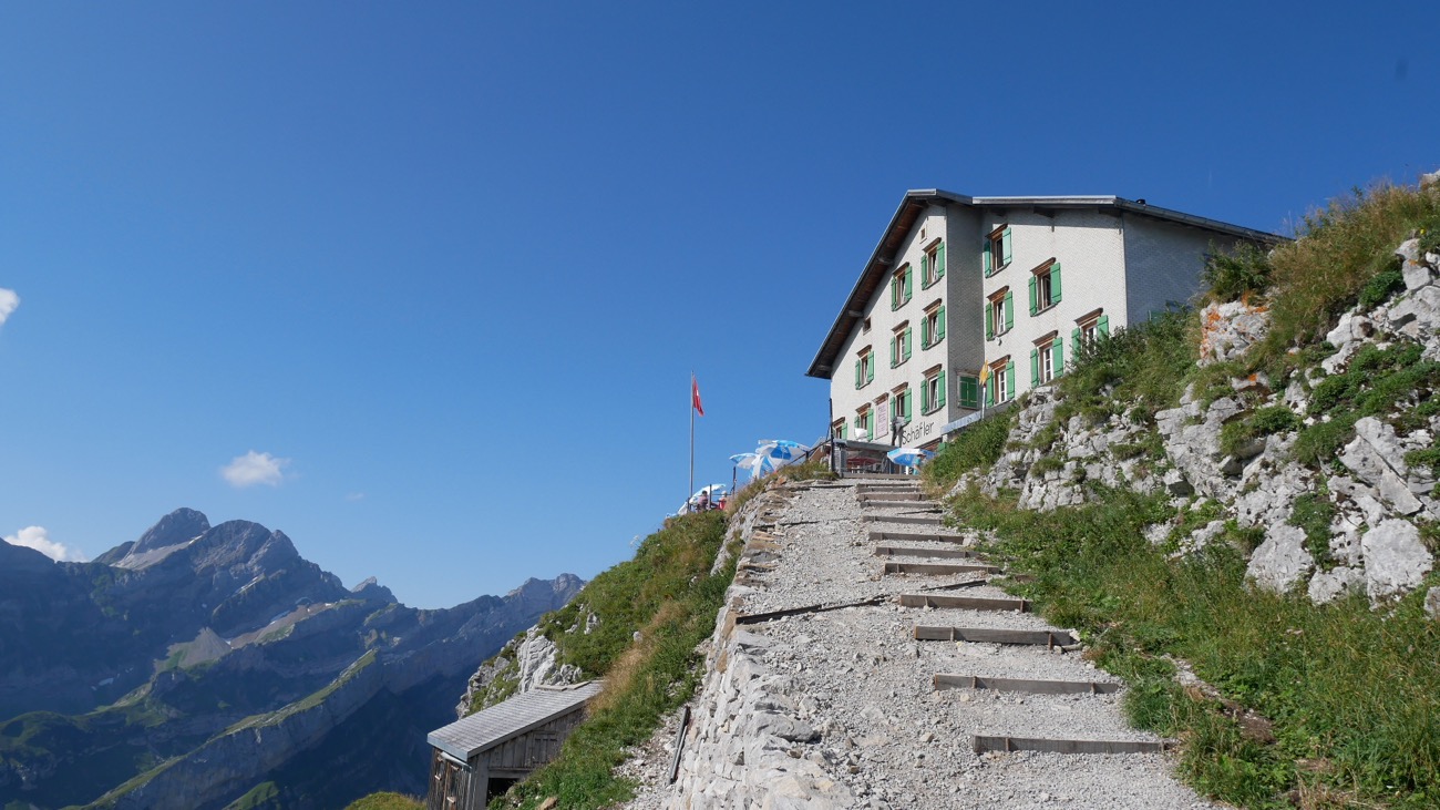
The path heading up to Berggasthaus Schafler
Once you reach Schafler, the views and fun really begin.
A little ahead of Schafler, you’ll experience the metal mountain ropes for the first time on this hike. The path gets steep here, so stick hold! Then you’ll drop down and round the mountain, have fun with a metal ladder, then once the adrenaline subsides, take in the views. They are incredible.
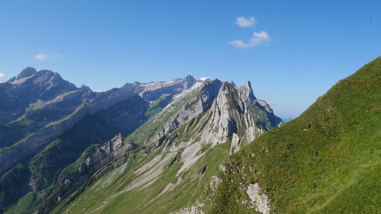
Views from near Schafler, in the Swiss Alps
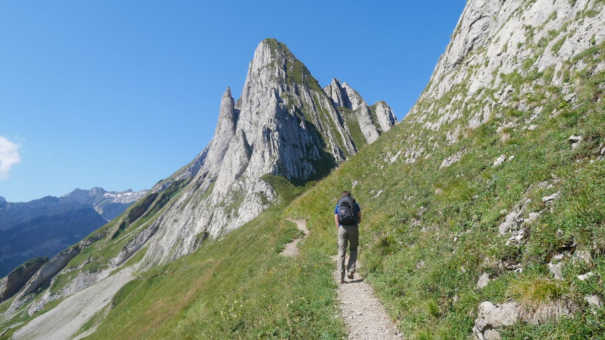
For this route, take the path below the pointy rock!
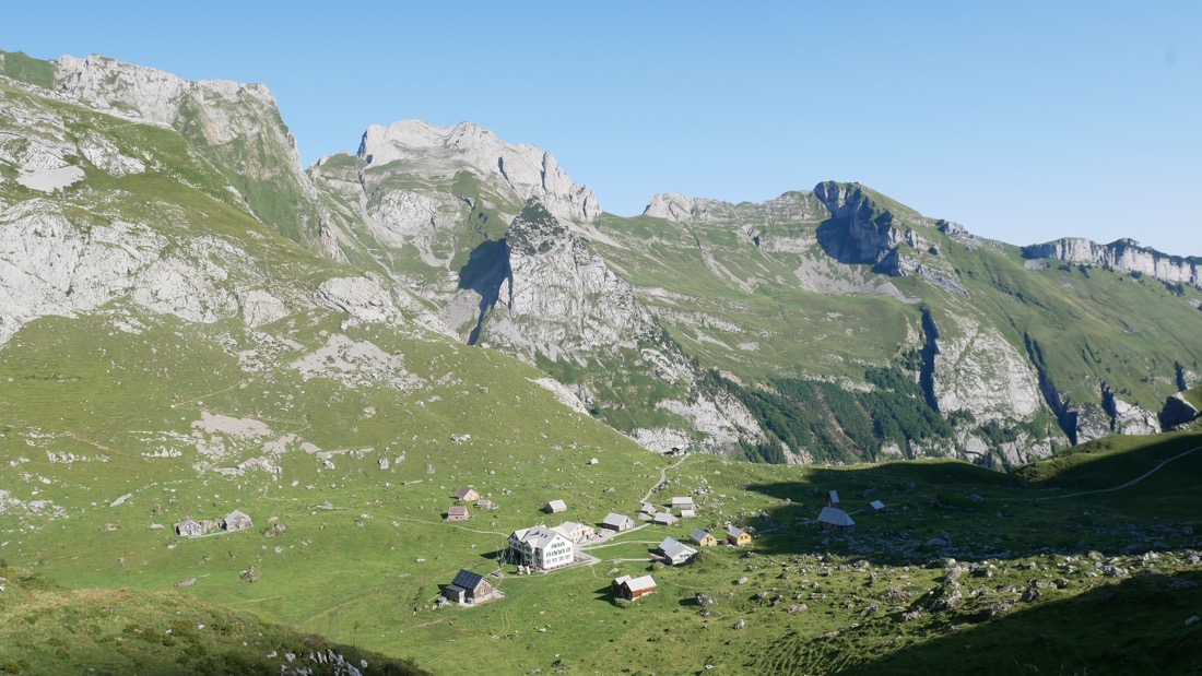
Take the lower path and drop down to Mesmer, where you can have a drink and a bite to eat (for the rosti with the egg on top if you’re hungry!)
From Mesmer, it’s then downhill all the way past cows, donkeys waterfalls and stunning, lush farmland.
Looking down towards Mesmer
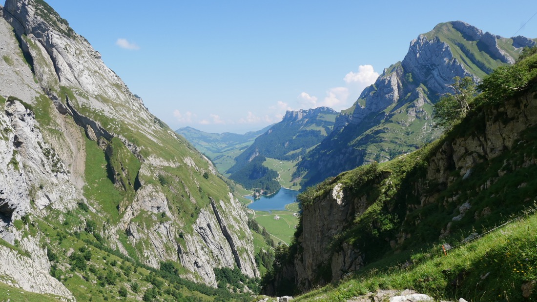
Views of Seealpsee from near Mesmer
This hike takes in some of my favourite scenery in the Swiss Alps, so I hope you enjoy it as much as I did!
2) WASSERAUEN > EBENALP > SANTIS > > MEGLISALP > MESMER > SEEALPSEE > WASSERAUEN
- Estimated time – 2 days (day 1: 7 – 8 hours, day 2 – 4 hours)
- Difficulty – difficult (precarious in many places)

This second Swiss Alps hike is an extension of the first, and duplicates the route we took for the whisky trek.
Following the directions from the first route, when you reach the pointy rock (Altenalpsattel), for this route, you head up and round it. It’s a steep climb with many switch backs, and remember, you’re at 1900m here, so take it easy.
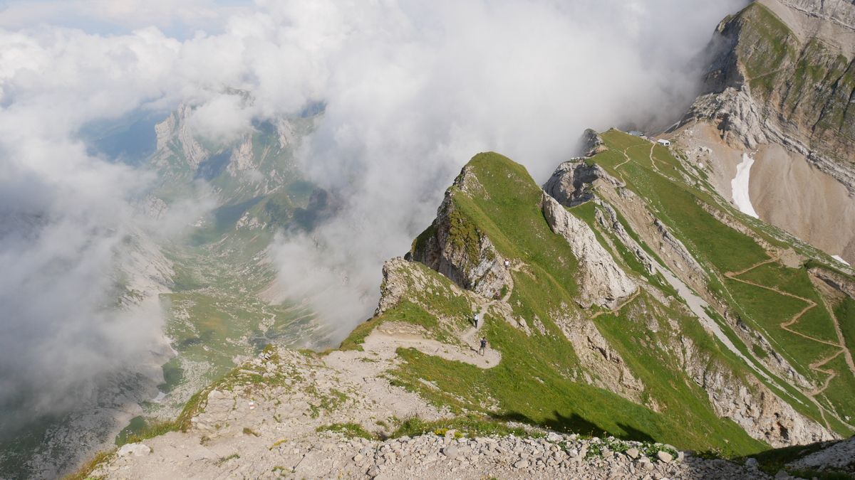
From here, you head on the North side of the mountain side for a time, before crossing back over at around 2100m. At this point, the looming Santis comes into view, and you’ll probably have plenty of snow on the ground.
I won’t lie, the last stretch up to Santis is tough. Tough because of the snow, and tough because of the type of hiking you have to do. There are metal steps built into the rock in many places, the path becomes incredibly steep, so this section isn’t for the faint hearted.
For example:
View this post on Instagram
We stopped at Alter Santis for some lunch and a drink, and if the weather is bad, there are two indoor restaurants to choose from.
From here, the next stretch of mountain path is quite steep and narrow, so stick hold of the those metal ropes.
You’ll encounter more mountain steps, and eventually you’ll peer over a ledge and be presented with the view of the Lisengrat – the ridge that takes you to Rotsteinpass.
This view really does take your breath away…
The journey from Ebenalp to Rotsteinpass (at the end of Lisengrat) should take around 7 hours at a decent pace, but much longer if the weather is bad and you need to stop a lot.
As such it’s worth booking accommodation ahead of time, either at Alter Santis, or Rotsteinpass, which is where we stayed (75 CHF for a dorm bed, breakfast and a two-course dinner with a drink).

Looking back towards Rotsteinpass
The following day, the drop down to Meglisalp is a lovely bimble amongst rugged, lush farmland.
Looking down towards Meglisalp
You should arrive at Meglisalp after around 1 hour.
My suggested route then takes you back up and over to Mesmer, which then follows the route from the first recommended hike, HOWEVER, the path down to Mesmer from here is very steep, and is a metal rope clinger for most of the way.
You do have options here, including head directly towards Seealpsee, which should see you arrive much sooner, but I don’t know this particular route well enough to tell you what it’s like.
Your final evening will be spent either in Seealpsee (why would you not, have you seen the views below?!) or alternatively, you can continue to hike from Seealpsee to Wasserauen (40 – 50 mins) and get the train back to Appenzell.
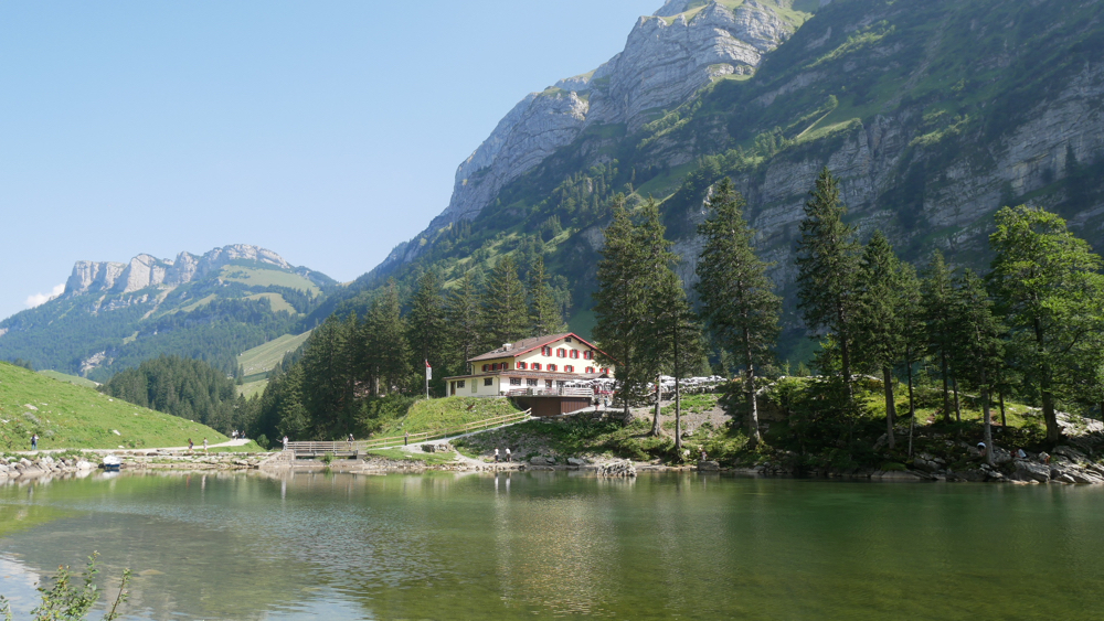
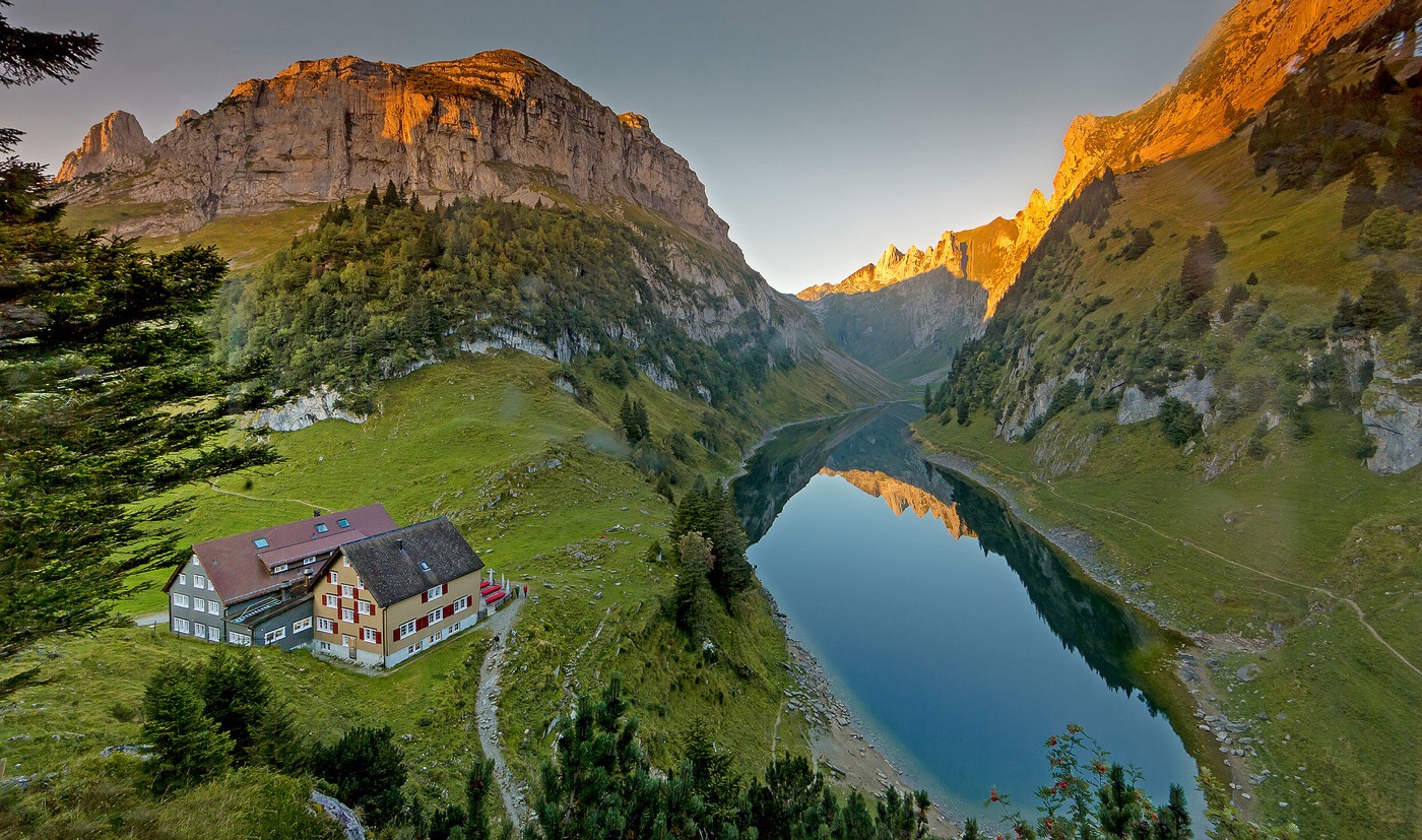
Berggasthaus Seealpsee, next to the lake
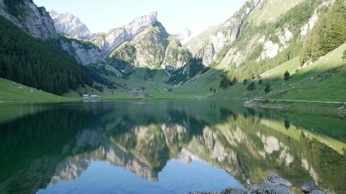
The view back up the valley towards Santis. Look at that reflection!
What I do know is this Swiss Alps hiking route has some of the best alpine scenery in the world. I said at the time, this was one of the most scenic hikes I’ve ever done..and that includes Machu Picchu and the Tongariro Crossing in New Zealand.
3) BRÜLISAU > BOLLENWEES > MEGLISALP > MESMER > SEEALPSEE > WASSERAUEN
- Estimated time – 2 days (day 1: 2.5 – 3.5 hours, day 2: 4 – 5 hours)
- Difficulty – difficult (precarious in many places)
For this last recommended hike, as suggested to me by the team at Santis Malt, you take in the views of another valley, located further South and West.
Taking the Brulisau cable car up to Alp Sigel, and from there walk to Berggasthaus Bollenwees at lake Fählensee, where you stay for the first night, at a marvellous lake side location.
The stunning location of Bollenwees. Photo source: Appenzell.ch
On your second day, starting off at Bollenwees, walk up passing Bötzel to Meglisalp, and then follow the route shown in number two above, over to Mesmer, then down to Lake Seealpsee to spend your second night.
HAPPY HIKING IN SWITZERLAND!
There you have it! Three incredible routes across the Alpstein. Sadly the photos don’t do any of the scenery justice, so you’ll just have to go and visit and see for yourself 🙂
Want more? Check out my whisky trek vlog below, which covers a lot of the scenery from hiking routes 2 and 3 above.
If you have any additions for hiking elsewhere in Switzerland, please feel free to comment below.


Leave a Reply
Want to join the discussion?Feel free to contribute!